Free email delivery
Please sign up for email delivery in the subscription area to the right.
No salesman will call, at least not from us. Maybe from someone else.
Rattlesnake Season
[by Chuck Almdale]
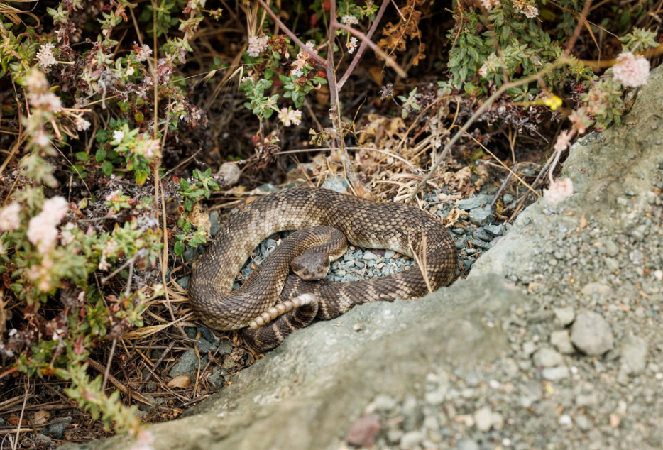
I was birding with a friend in O’Melveny Park near Granada Hills in the San Fernando Valley back on March 30, and we met a trailside rattlesnake. It was not happy to see us.
A little more detail. We had stopped to check out a hillside bushtop singing bird, which turned out to be a Rufous-crowned Sparrow – a good bird – and our Merlin app confirmed the insect-like (to my ears) song ID. Meanwhile, down the brushy slope behind us, some park maintenance person had turned on a sprinkler. After 10-20 seconds and the sprinkler not changing its sound one whit, I decided to look around to see where this sprinkler was. The sound was unusually steady, a high ssssssssss, there was no sign or sound of water falling anywhere, and downslope there was only brush. What park sprinkles their untamed hillside bushes at 11 AM? And the sprinkler seemed close. But it didn’t sound like a rattlesnake. Well…maybe a little.
It turned out to be a rattlesnake all right, coiled up, in the shade of a bush about two feet the other side of the trail, and when I saw him in my binos, it was staring straight at me. That sssssss sound really didn’t sound like any rattle I’ve ever hear from a rattlesnake, as it was seamlessly constant – not rattley – and higher pitched than the typical rattle, but it didn’t look like it was hissing. We looked at it a bit, then continued down the trail, mentioning the snake to passersby and suggesting they keep their eyes open. Three other groups had also seen rattlesnakes that day, further up the trail. I’ve birded in O’Melveny dozens of times, and never seen a rattlesnake. In nearby Placerita Canyon, I’ve seen them several times.
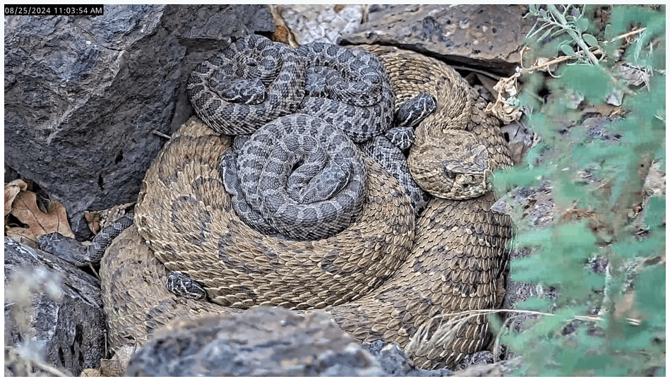
Rattlesnakes gather in underground or rockpile dens for the winter. When they emerge in spring and you’re in the area, it might seem like they’re everywhere. So I’ve heard and read, and I suspect that is what was going on.
Because rattlesnakes are now out and about, people have been bitten, and two people in our area have died, I thought I’d assemble a few tips and comments.
Tips from California Fish & Wildlife (link)
- Stay alert when outdoors.
- Wear sturdy boots and loose-fitting long pants. DO NOT wear sandals or flip-flops in brushy areas.
- Stay on well-used trails. Avoid tall grass, weeds, and heavy underbrush.
- Check rocks, stumps or logs before sitting down.
- Shake out sleeping bag and tent before use.
- Let others know where you are going, when you plan to return, and carry a cell phone. Hike with a companion when possible.
- DO NOT grab “sticks” in water. Rattlesnakes can swim.
- DO NOT let dogs off leash. Dogs are at increased risk when sniffing the ground near brushy areas.
- DO NOT try to touch or handle a snake, dead or alive. Dead rattlers may still inject venom shortly after death.
Tips from other sources
- Don’t pick up or get close to snakes. A 10 ft. distance is minimum.
- Make sure you can see where you plan to step or put your hands (e.g. when climbing rocks).
- Step on, not over, large rocks or logs.
- Avoid hiking alone so that you have help in case of an emergency.
- Scan the ground ahead of you as you walk, jog, or ride.
- Listen for the buzz of a rattlesnake’s rattle warning you it is there.
- Most bites result from trying to catch, drive off or kill the rattlesnake. Avoid it and go on your way.
Project RattleCam has livestreaming and archived videos of rattlesnakes.
Comments
A California study found two-thirds of rattlesnake bites were on the hand or arm, and 80 percent of victims were young men. Most bites occur from handling or accidentally touching snakes. [Sonoma Co. Parks]
In the unlikely event that you are bitten by a rattlesnake, remain calm and have someone call 911 immediately. Keep the affected limb below your heart. Don’t use a tourniquet or try to remove the venom yourself. If you are alone, call 911 or walk calmly to the nearest phone. Avoid running, but seek medical care as soon as you are able is vital. [East Bay Regional Parks]
A startled rattlesnake may NOT rattle before striking defensively. They also may not deliver an envenomed bite – a ‘dry bite’ may be used as a warning because venom creation and use can be energetically expensive for the snake. However, all bites from a rattlesnake should be treated as a venomous bite until appropriate medical attention is provided.
- Rattlesnakes are sensitive to ambient temperature and adjust their behavior accordingly. In warmer weather, you may see one basking in the sun to raise it’s body temperature.
- In Spring and Summer – Most active at dawn, dusk, and night to avoid overheating.
- In Fall and Winter – Inactive, and some may go into brumation (a state of dormancy with periods of activity), for several months in rock crevices, rodent burrows, or thick vegetation.
- Often multiple rattlesnakes may gather and establish dens during the colder months. These are often in rocky crevices where heat is retained, but may be found underneath homes or man-made structures. [Calif. Fish & Wildlife]
Rattlesnakes are important mid-level predators. They help with population and disease control by eating rodents that carry diseases like Lyme disease and plague, and which would otherwise over-reproduce and eat down all of our crops and native plants. And by eating those small rodents, they also package that energy into a nice big snake-shaped sausage for top predators like mountain lions or owls to eat. And, rattlesnake venoms are currently being studied for drug development. There’s a drug that’s been on the market for decades now that is derived from rattlesnake venom. If you know someone who’s had a heart attack or gotten a stent in their heart or been treated for being at a high risk for blood clots, they might have been treated with this drug. We haven’t been able to synthetically develop anything in a lab that is nearly as good. [Cal Poly News]
If you see a rattlesnake out in the wild, like on a hiking trail, just give it space. Stay 10 feet away from it and let it move along its way because you’re in its house. If rattlesnakes are in someone’s yard or in their house or that sort of thing, the evidence-based best approach is to relocate that rattlesnake. Best thing to do is call a professional. There’s also a website called freesnakerelocation.org where people can find a relocation service in their area.
Partial closure 405 N in Sepulveda pass 4/18/26
[Posted by Chuck Almdale]
The northbound 405 through the Sepulveda Pass between Skirball Center and Ventura Blvd. will be reduced to three lanes, 10pm Friday 4/17 through 5am Monday, 4/20. Also closed are: northbound off-ramp to Getty Center Drive, Skirball Center on-ramp to 405 N. Supposedly the southbound lanes will not be affected, but web sources didn’t agree on this.
If you’re planning on coming on our trip to Bear Divide banding station in the mountains above Sylmar, north of the San Fernando Valley, please take this possible slowdown into account, especially if you’re planning on arriving at the carpool meetup spot 6:45-7:00 am.
I’m not certain that three open lanes at 6:30-7:00 am on the northbound 405 constitute massive tie-ups, but there will be slowing at the least.
Bear Divide field trip: Sat. 18 April, 2026 7:30 am
[Posted by Chuck Almdale]
On Saturday, 18 April, we’re going to visit Bear Divide Bird Banding location in the San Gabriel Mtns. above Sylmar, located on the mountain ridgetop between Fwys #14 & #210. The site was embedded in a cloud when we visited last year and the banding station was closed, yet we found another twenty or so people, bundled up, standing around in the fog, hoping to see birds. It became a bit of a party, as when a crowd of birders gather at a rare bird stake-out spot, hoping for a glimpse of a lifer and chattering away while they wait. We located and identified about two dozen species in the fog, including ravens croaking like foghorns in the misty distance, and Wrentits bip-bip-bipping away.
When it’s fog-cloudy, they call off the banding because 1) most of the birds know enough to fly above the fog if it’s not too high, and (in my opinion) 2) it’s cold, fingers get cold, it’s harder to manipulate the tools and the live birds and thus the fun dissipates faster than the fog.
This year, the road up the north slope is closed due to washout and collapse repairs, so we must use the route up the south slope.
Trip reservation necessary
Contact leader: Armando Martinez 310-428-6845 or email armando.martinezmarquez@gmail.com.
If our plans change as they can due to fog/cloud, we’ll need to contact you.
For Carpooling
Contact Armando as above for the north valley carpooling meeting location.
Time: Arrive 6:45 – 7 am. We leave here at 7 am.
Bring: Binoculars, clothing layers, water, snack.
Carpooling:
We recommend gathering at the carpool location as parking can be limited at the banding location. We also recommend that that all visitors read the banding station’s page: https://beardividebanding.com/visit/. Their primary purpose is banding birds, and cooperation from visitors is needed to get the job done in a manner friendly to both birds and birders. They are also happy to take donations. $5-10 per person is suggested. SMBAS is not covering these donations.
Weather Predictions: NWS camp 9, then “hourly weather forecast” is “somewhat reliable” for predictions for this area.
Driving yourself?
Try to arrive by 7:30am at the banding location. You’ll have to figure it out yourself how long that will take you on a Saturday morning. Expect it to take at least 20 minutes to travel up Little Tujunga Canyon Road to the banding site.
Using an in-car GPS routing system? Don’t let it send you on the northern route using Hwy #14 and Placerita Cyn. Rd. or Sand Canyon Rd. The section of Little Tujunga Cyn. Rd. north of Bear Divide is closed due to repairs. You can’t get through that way.
General directions: Exit #210 Fwy at exit #8 Foothill Blvd. Turn north (left), go approx. .2 mile to Osborne St. and turn left. Osborne becomes Little Tujunga Cyn. Rd. Continue uphill roughly 10 miles of winding road to the Bear Divide Fire Station and picnic grounds access road (Santa Clara Truck Trail) and turn left. Bear to the right to large dirt parking area on right and park out of the way.
Altitude: ~1700 ft., might be overcast and foggy, might be sunny.
Alternative in case of thick clouds:
Depending on the fog, we may use the option of birding at Wilson Canyon in Olive View, NE of Sylmar. This spot is often very birdy, especially in spring. If it’s clouded in at the divide there may be extra birds downslope at Wilson Canyon. There is a $5 parking fee which you pay by putting cash into an envelope and then into a slotted box. No credit card or telephone payments possible.
Address: 14450 Olive View Drive, just east of Olive View Hospital.
Directions: Take #210 Fwy to exit #2 Roxford St. Turn north, follow the eastward curve where it becomes Olive View Dr., continue past Olive View-UCLA Medical Center on north side of road to the park entrance road on left (signed). Pay your $5 fee and continue up the hill on the narrow paved road. At the top it becomes dirt. Turn left. In about 1/10 mile, it curves to the right and ends at a large dirt parking area. Meet here, if we decide to come here. You can always come here on your own, by the way. It’s a great birding spot. And…if you ever feel like hiking over the mountain ridge, start from here and end up in Placerita Cyn.; it’s fire roads and trail all the way.


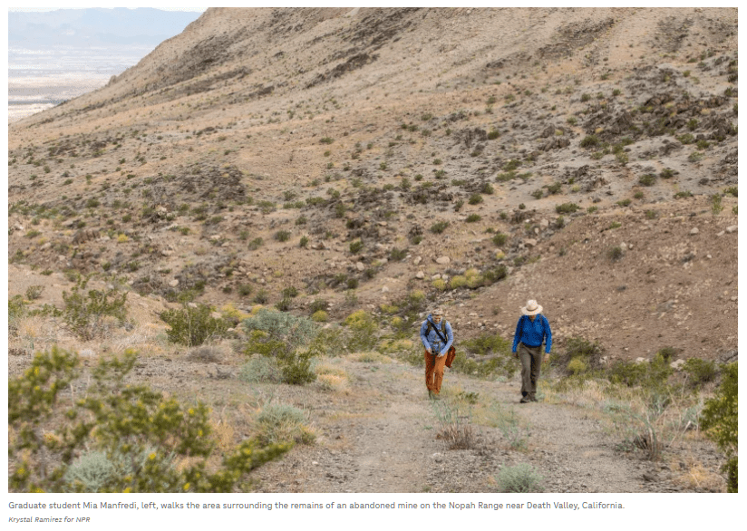
Death Valley Sage
[by Chuck Almdale]
National Public Radio (NPR) recently did a report of the very rare Death Valley Sage (Salvia furneria).
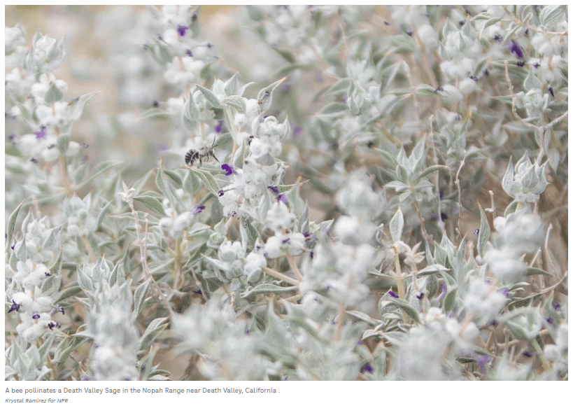
Most of the report focused on the work of botanist Naomi Fraga of the California Botanic Garden. For more than 15 years she has been trying to collect seeds from this plant, which will then be put into a vault for safekeeping, similar to the giant Svalbard (Norway) Global Seed Vault containing the seeds of important crop plants from around the world. She did collect many seeds from many other plants, but so far she’s empty handed with Salvia funeria. In 2026 the desert really bloomed, hope springs eternal, and she trying again.
Read the report, see the photos and listen to the 5-minute interview.
https://www.npr.org/sections/the-picture-show/2026/04/01/nx-s1-5749446/botanist-search-seeds-rare-death-valley-sage
Other web pages on Salvia funeria: Calscape, CNPS, Wikipedia
Read Naomi Fraga’s bio: https://naomifraga.com/naomi/
The California Botanic Garden where Naomi works, has their own website https://www.calbg.org/, well worth a look for anyone interested in native plants. You can:
- Visit their garden Tue-Sat 8am-7pm (what’s beautiful today)
- Become a member, get free admission to the garden,discounts on purchases, and more
- Volunteer
- Buy native plants
- Learn about the seed bank and buy seeds from over 6,000 California plant species
- Get their very interesting 12-page monthly Oak Notes newsletter
- Take classes & attend events
- Attend Seminar series’
- Donate to help
California Botanic Garden
1500 N. College Ave., Claremont CA 91711
909-625-8767 | info@calbg.org
Bear Divide field trip: Sat. 18 April, 2026 7:30 am
[Posted by Chuck Almdale]
On Saturday, 18 April, we’re going to visit Bear Divide Bird Banding location in the San Gabriel Mtns. above Sylmar, located on the mountain ridgetop between Fwys #14 & #210. The site was embedded in a cloud when we visited last year and the banding station was closed, yet we found another twenty or so people, bundled up, standing around in the fog, hoping to see birds. It became a bit of a party, as when a crowd of birders gather at a rare bird stake-out spot, hoping for a glimpse of a lifer and chattering away while they wait. We located and identified about two dozen species in the fog, including ravens croaking like foghorns in the misty distance, and Wrentits bip-bip-bipping away.
When it’s fog-cloudy, they call off the banding because 1) most of the birds know enough to fly above the fog if it’s not too high, and (in my opinion) 2) it’s cold, fingers get cold, it’s harder to manipulate the tools and the live birds and thus the fun dissipates faster than the fog.
This year, the road up the north slope is closed due to washout and collapse repairs, so we must use the route up the south slope.
Trip reservation necessary
Contact leader: Armando Martinez 310-428-6845 or email armando.martinezmarquez@gmail.com.
If our plans change as they can due to fog/cloud, we’ll need to contact you.
For Carpooling
Contact Armando as above for the north valley carpooling meeting location.
Time: Arrive 6:45 – 7 am. We leave here at 7 am.
Bring: Binoculars, clothing layers, water, snack.
Carpooling:
We recommend gathering at the carpool location as parking can be limited at the banding location. We also recommend that that all visitors read the banding station’s page: https://beardividebanding.com/visit/. Their primary purpose is banding birds, and cooperation from visitors is needed to get the job done in a manner friendly to both birds and birders. They are also happy to take donations. $5-10 per person is suggested. SMBAS is not covering these donations.
Weather Predictions: NWS camp 9, then “hourly weather forecast” is “somewhat reliable” for predictions for this area.
Driving yourself?
Try to arrive by 7:30am at the banding location. You’ll have to figure it out yourself how long that will take you on a Saturday morning. Expect it to take at least 20 minutes to travel up Little Tujunga Canyon Road to the banding site.
Using an in-car GPS routing system? Don’t let it send you on the northern route using Hwy #14 and Placerita Cyn. Rd. or Sand Canyon Rd. The section of Little Tujunga Cyn. Rd. north of Bear Divide is closed due to repairs. You can’t get through that way.
General directions: Exit #210 Fwy at exit #8 Foothill Blvd. Turn north (left), go approx. .2 mile to Osborne St. and turn left. Osborne becomes Little Tujunga Cyn. Rd. Continue uphill roughly 10 miles of winding road to the Bear Divide Fire Station and picnic grounds access road (Santa Clara Truck Trail) and turn left. Bear to the right to large dirt parking area on right and park out of the way.
Altitude: ~1700 ft., might be overcast and foggy, might be sunny.
Alternative in case of thick clouds:
Depending on the fog, we may use the option of birding at Wilson Canyon in Olive View, NE of Sylmar. This spot is often very birdy, especially in spring. If it’s clouded in at the divide there may be extra birds downslope at Wilson Canyon. There is a $5 parking fee which you pay by putting cash into an envelope and then into a slotted box. No credit card or telephone payments possible.
Address: 14450 Olive View Drive, just east of Olive View Hospital.
Directions: Take #210 Fwy to exit #2 Roxford St. Turn north, follow the eastward curve where it becomes Olive View Dr., continue past Olive View-UCLA Medical Center on north side of road to the park entrance road on left (signed). Pay your $5 fee and continue up the hill on the narrow paved road. At the top it becomes dirt. Turn left. In about 1/10 mile, it curves to the right and ends at a large dirt parking area. Meet here, if we decide to come here. You can always come here on your own, by the way. It’s a great birding spot. And…if you ever feel like hiking over the mountain ridge, start from here and end up in Placerita Cyn.; it’s fire roads and trail all the way.


